 One of the most fun activities I've done in Ulster County is ride on the Twilight Limited Train on the Catskill Mountain Railroad. Twice each summer, the CMRR has a nighttime ride that includes a fun stop at the Phoenicia Train Station where they have live music and snacks. In addition to dancing to Bluegrass tunes, you can visit the Empire State Railway Museum during the stopover in Phoenicia. The train then heads toward the Ashokan Reservoir before turning back to Mount Tremper Station to drop everyone off.
 Although the Twilight Limited runs only twice a year, there are regular rides during the week plus other special rides, like their Fall Foliage Rides. You can even charter a train for a special occasion.
 During the Twilight Limited, we enjoyed the sounds of Earl Pardini and the Slide Mountain String Band. They played a fairly long set at the station in Phoenicia and then joined us for the remainder of the ride. Someone else on our train ride posted footage from the trip on YouTube. It includes several pictures (some blurry) and video from the ride. It includes music from the band and some great footage of the merriment on the platform in Phoenicia. The video captures several train passengers dancing the Virginia Reel, a folk dance dating back to the 17th century.
 The old ticket booth inside the Phoenicia Train Station/Museum is pictured above. The YouTube video includes shots of a lot of the pictures and memorabilia inside the museum.
 The train is quite impressive on the interior as well. Above is a photo of the enclosed car. There were also two "outdoor" cars that had benches running along the center and were open to the elements - perfect for the weather on Saturday night.
 The CMRR is an extension of the Delaware and Ulster Railroad, which was completed in 1900. The railroad helped build up the Catskills as a vacation/retreat destination for people from New York City, and its fortunes rose and fell along with those of the mountain houses in the region. More information about the history of the railroad is available here.
Overall, the ride was a lot of fun, and I'm definitely looking forward to going back for the Fall Foliage Train. The Mount Tremper Train Station is located just outside of Phoenicia and is the main starting and stopping point for the Esopus Line. You can also take the train along its Kingston Line with the train starting at Kingston Plaza. The Kingston ride focuses mainly on the city of Kingston and doesn't appear to go into the countryside like the Esopus Line.
Overall, the ride was a lot of fun, and I'm definitely looking forward to going back for the Fall Foliage Train. The Mount Tremper Train Station is located just outside of Phoenicia and is the main starting and stopping point for the Esopus Line. You can also take the train along its Kingston Line with the train starting at Kingston Plaza. The Kingston ride focuses mainly on the city of Kingston and doesn't appear to go into the countryside like the Esopus Line.


 The Picnic Lodge is the main point of entry for day trippers and is the only location for day trippers to purchase meals. Day trippers are not allowed inside the main house, although you can access the trails around the property. Below is the kitchen area of the Picnic Lodge.
 As the name suggests, you can picnic at the Picnic Lodge. There are comfy rocking chairs on the front porch (the same rocking chairs that you see all along the lakefront side of the main house).
 Here's a good
  Day meals are allowed for breakfast, brunch, and dinner. For an upfront-paid fee, you get your meal plus access to the guest parking lot at the main house, and you are allowed to visit the first floor of the main house - including the cool gift store. Meals can be pricey, so I suggest going in for breakfast - that also gives you the whole day to wander around.
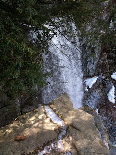

 The video below (hope it works - it's not quite optimized for the blog video player - sorry about any problems viewing it) was taken at the top of the waterfall in Spring 2010 and shows the stream that feeds the falls as well as the drop off over the falls. You can see how beautiful the area is.
  I've talked to a lot of people that have visited Lake

