One of the coolest (and shortest) hikes that I've found in the Ulster County area is the Shaft 2A hike. Located on the northwestern edge of the Minnewaska Preserve, the trail takes you to an 87-foot waterfall. To make the hike longer, you can also climb up the rock cliffs to take a trail that runs along the stream feeding the waterfall. Alternatively, at the top of the falls you can take a trail that runs toward the main part of Minnewaska. The optional trail will take you through the area of Minnewaska that suffered from a forest fire in April 2008.
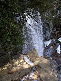
 One of the best times to visit Shaft 2A and the falls is during the winter when the falls freeze. The picture above shows some relative scale for the height of the waterfall. Below is a shot from behind the frozen waterfall.
 The video below (hope it works - it's not quite optimized for the blog video player - sorry about any problems viewing it) was taken at the top of the waterfall in Spring 2010 and shows the stream that feeds the falls as well as the drop off over the falls. You can see how beautiful the area is.
 If the video doesn't work, it is also on YouTube. You should be able to view it here. You can view another video I shot from down below the falls here. Also, you can view one of my hikes (with pictures) to Shaft 2A and into Minnewaska. It is viewable at EveryTrail here.
Information about how to get to the trail can be found on the Shaft 2A page at WikiPaltz. There is no formal parking area - just a dead-end road. From the road, the hike to the falls takes about 20 minutes. Some parts of the hike are alongside a fairly steep incline and can be quite slippery in the winter. There are great views of the falls from several vantage points along the trail. To get to the top of the falls, you will have to cross the stream and head up the cliff area to the left of the falls.
No comments:
Post a Comment